New risks and new uses of marine and coastal space
Axis 3

Ile de Noirmoutier- 2014 (photo credits : LETG-Univ Nantes)
The risks linked to or amplified by the changes affecting the marine and coastal space (emergence of new uses, climate change, etc.) are still largely undocumented, be it in their occurrence or their impacts on coastal territories. The management of marine space (uses, resources, territories...) is becoming a key issue. Thus, the aim of this axis is to apprehend and understand these “new” risks in the way they are related to one or many changes influencing a given territorial system. More precisely, to try to identify, through an integrated and interdisciplinary way, the elements of risk definition and to model the key mechanisms of the emergence and control of risks. Through this objective, the third axis brings a complementary approach to the first two axes as the observation of marine and coastal systems starts with human activities, while the first two axes approach the subject matter through biodiversity and resources. This third axis involves the following disciplines: public administration, law, economy, geography, history, sociology, biology and ecology. To do this, two actions defined around those issues (actions 3.1 & 3.2) will allow for system analysis by targeting specific risks. Furthermore, a horizontal action linking the first two (action 3.3) will help analyse, through an international comparison, the governance process at the scale of territories faced with the two most important risks studied.
The impact of global changes on coastal territories (action 3.1)
The first action deals with the impact of global change on coastal territories through two ways: the risk of coastal flooding and those associated with the proliferation of invasive species. For coastal flooding, research will commence with the spatial delineation of hazard zones of coastal flooding based on the knowledge of old and recent events that have affected the coastal territory of the Pays de la Loire. This action incorporates scenarios of rising sea level, mapping of the issues faced in submersible areas, a cost-benefit analysis, development proposals and a reduction of the vulnerability of the territories. Results will be presented through hazard maps with accurate data on the cost of prevention and protective measures, as well as the adaptations to risks of coastal flooding. As for invasive species, the impacts of their proliferation on coastal territories will be studied.
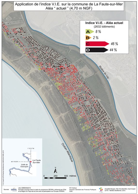
Applying the Index VIE after Xynthia on Faute sur Mer community (work : A.Creach)
Changes and risks in the marine fisheries sector (action 3.2)
The second research action (3.2) targets the apprehension of the changes and risks that the marine fisheries sector must face. Numerous changes are taken into consideration: climate change, market organisation (interconnection of fish markets, contracting), regulated access to fishing areas (introduction of new uses like marine energies, ecosystem management and spatialisation of resources). The risks incurred by fishermen (variability of prices and incomes, biological processes, institutional risks linked to management policy) are analysed using a variety of complementary methodologies (modelling, development scenarios, surveys) so as to encourage cross-knowledge appreciation of changes and risks by professionals. This action continues the effort to integrate the knowledge and work started in the research project GERRICO while focusing on the integration of behaviour and risks.
Comparative analysis (France-Canada) of governance in the event of new risks and uses (action 3.3)
The third action is closely linked to the work of the other two actions and related to international comparison (France-Canada). Its aim is to compare the methods and analyses specific for the comprehension of the governance of coastal zones and also to cultivate questions on risk across territories. More precisely, it is (i) to build a French-Canadian shared methodology for analysing the governance process; (ii) to test this method experimentally on issues of marine submersion and in the marine fisheries sector. Moreover, the perspective is to place the IUML on the playing field of international expertise in coastal zone management from thematic and geographic areas likely to diversify (networking).
Through combined efforts, the research conducted as part of this axis will integrate disciplinary approaches at the level of SHS and consolidate the theoretical and methodological contributions related to maritime risks in favour of the integrated axis of the project.
Axis coordinators : Pierre Petitgas, Ifremer & Brice Trouillet, Université de Nantes